Lesson One
Geology and the Formation of New England
Our Earth's history began some four and a half billion years ago, as the planet of molten rock began to cool. Over the course of several million years, a thin outer shell formed. This shell broke apart into continent-sized landmasses. This "crust" is about eighteen miles thick and floats atop a seething, semi-molten rock "mantle" about eighteen hundred miles thick. The next two thousand miles below the mantle are molten rock surrounding the Earth's solid inner iron core. If the Earth were the size of an apple, the crust that supports life would be thinner than the skin of the apple.1
The seemingly immovable anchored land masses continuously collide, separate and move, all in response to the molten energy of the mantle on which they float. We are accustomed to thinking of the continents as discrete bodies permanently separated by vast stretches of ocean. In fact, they have come together at least four times in the last two and a half billion years to form giant supercontinents.2
As the surface of ancient Earth cooled, water vapor formed, and generated lashing rains that filled the oceans. The planet could not support life, and even rocks do not survive from this period.3 The next three billion years witnessed the emergence of oxygen-breathing, cellular life forms.4
The passage of time in geologic terms is so vast that it is difficult to comprehend its scope. A useful exercise is to have students stretch out their arms. The distance they span represents the passage of time from the formation of the earth to the present. From the right wrist to the tips of the fingers represents most of the history of life on Earth. The tip of the fingernail represents human presence on Earth.
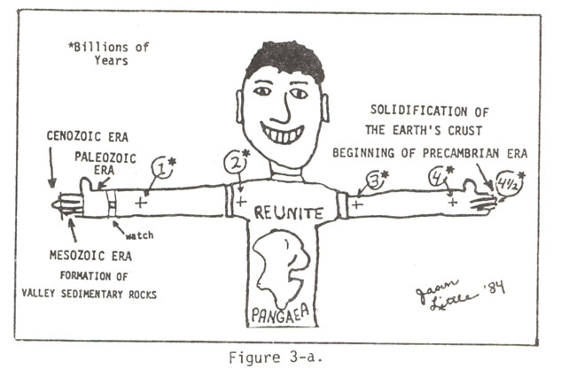
Figure 1: Richard D. Little, Dinosaurs, Dunes, and Drifting Continents, p. 5
The following geological background focuses on the northeastern portion of New England and the Connecticut River Valley in particular. Studying the ancient geology of a region helps students to understand its effect upon human presence and habitation. As part of a curriculum dealing with the history of the town of Deerfield, Massachusetts, and the surrounding region, this geologic background is designed to complement and enrich students' understanding of this particular area. Teachers using these lesson plans who wish to tailor them to their own region's geological features can and should introduce information and resources highlighting that history.
The Connecticut River Valley possesses an interesting and significant geological history. As geologist Richard Little points out, it includes "[o]ceans, mountains, earthquakes, dinosaurs, lava flows, glaciers, rivers and people." It is, Little contends, "one of the few places in the world where such diverse history can be seen in so small a geographic area."5
Six hundred million years ago, during the Paleozoic Era, a warm, shallow sea covered most of present day North America. The landmass was at that time about twenty degrees south of the equator, occupying approximately the same position as Brazil does today. Because this sea was only hundreds instead of thousands of feet deep, it fostered a vast array of plant and animal life.6
Three hundred million years ago, the drifting continents collided yet again and formed the supercontinent of Pangaea. The vast, warm inland sea drained and great mountains rose. The Appalachians formed as Africa and southern Europe crashed into southeastern North America.7 It is here that the story of the Connecticut River Valley begins.
When Pangaea broke apart, it separated along new lines. North America gained landmass at Africa's expense. As the ever-restless landmass stretched and cracked, valleys and basins formed, among them the Connecticut River Valley. The rivers flowing through the Valley emptied into a "newly-opening Atlantic Sea."8
The Connecticut River Valley harbored huge lakes. As they dried, they left a rich geologic record. Old lakebeds preserved mud cracks, insect trails and dinosaur footprints, providing a glimpse into the Mesozoic Era. Dinosaurs attracted to lakes left footprints in drying, exposed lakebeds. Some of these prints dried and were covered by protective sediments washed into them when it rained. The Valley's oxygen-rich sediment quickly decayed the bones of these and other creatures, making the Connecticut River Valley a mecca for dinosaur prints but with a meager bone record.9
As continental drift divided the continents, geologic activity continued to shape the valley region. Earthquakes were common. During the Mesozoic Era, volcanic activity, and later erosion, would form the Holyoke Mountain Range. The eroded volcano cones of the Pocumtuck Range overlooked the northern valley, and the future settlement of Deerfield, Massachusetts.10
The Valley gradually filled in with sediment from the eroding mountains. In the late Miocene Epoch of the Cenozoic Era (about ten million years ago), the Valley floor began to warp upward several thousand feet. Old streams ran faster; some began cutting across soft rock and encompassing other streams. It was in this period that the Connecticut River formed, running two hundred miles from St Johnsbury, Vermont, to the Atlantic Ocean.11
The Ice Age was the next major geological event to shape the Connecticut River Valley. Ice ages occur when the Earth's temperature cools enough to keep ice forming at a rate faster than it can thaw. There have been at least twenty glacial advances of ice over the last two and a half million years. Many of these did not reach the Connecticut River Valley, but the most recent one did. The Wisconsinian Ice Sheet reached depths of up to two miles, and covered much of North America with ice.
The Wisconsinian Ice Sheet began to retreat one hundred and eighty thousand years ago. New England's glacier generally behaved, in Richard Little's words, like a "gigantic, passive ice cube." As the great ice sheet melted and receded north, it left behind glacial till to form many of the hills in New England. This till had been scoured from the land as the great ice sheet ground towards the Atlantic Ocean. Glacial till forms many recreational areas in southern New England, including Long Island.12
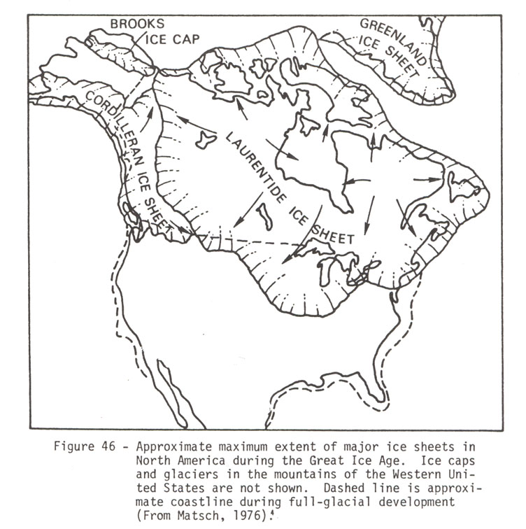
North America covered with an ice sheet-- Figure 46 from Richard D. Little, Dinosaurs, Dunes, and Drifting Continents.
A lasting memento of the ice age appeared about fourteen thousand years ago. As deltas of sediment formed dams across the valley, a large, inland lake grew in front of the Connecticut River Valley ice lobe. Fed by melt streams falling from the glacier, Lake Hitchcock covered an area some 150 miles long and twelve miles wide. It stretched from southern Vermont to Rocky Hill, Connecticut.13

Lake Hitchcock--Figure 50, from Richard D. Little, Dinosaurs, Dunes, and Drifting Continents, p. 61
Lake Hitchcock was named for Edward Hitchcock (1793-1863). A professor and, later, president of Amherst College, Hitchcock popularized the science of geology and led the movement to make geology part of the American college curriculum. He served as state geologist in Vermont as well as Massachusetts, and made many geological discoveries, including Lake Hitchcock.14
Hitchcock also joined the early serious study of dinosaur fossil prints. He went to Greenfield, Massachusetts in 1835 to investigate "turkey tracks" found there during sidewalk construction. This began a thirty-year fascination with fossil prints. He carefully identified and recorded one hundred and fifty-four different species. His wife, Orra White Hitchcock, was an accomplished artist. She assisted Hitchcock by sketching tracks and rendering geological features.
Hitchcock's collection of prints eventually numbered over ten thousand, and is now housed at Amherst College's Pratt Museum. Hitchcock and other researchers at first identified the prints as bird tracks, but the lack of accompanying feather impressions puzzled them. Not until 1859 at a meeting of the American Association for the Advancement of Science in Springfield, Massachusetts were the prints identified as dinosaur tracks.15
Hitchcock produced several notable works. His geology textbook was enormously popular and was the first American geology text that had not simply adapted a British work for an American market. Elementary Geology went through thirty-one editions in only twenty years.16
Edward Hitchcock died in 1863. In his lifetime, he had done more than any other single person to forward the popular study of geology. Giving his name to the ancient lakebed he discovered is a lasting tribute to the key role he played in the field of geology.
How long Lake Hitchcock survived is debatable. Geological evidence suggests that drainage may have begun to occur almost immediately, and that the lake lasted perhaps only a few thousand years--a mere moment in geological time. Richard Little believes that it may have drained in four "flood pulses" as the major sedimentary dam at Rocky Hill eroded. By then, Lake Hitchcock was a series of lakes partitioned by deltas deposited by streams.17
Lake Hitchcock's existence coincided with the arrival of humans on the North American continent. Crossing the land bridge exposed by receding oceans caused by the Ice Age, early man followed mammoths and other Ice Age animals onto the North American continent. There is no evidence, to date, of human presence at Lake Hitchcock. The native people of the region do have a creation story, however, that tells of a giant beaver killed in the middle of a lake and turned to stone. The "beaver" is a local landform, Mount Sugarloaf. The waters of Lake Hitchcock did indeed surround Mount Sugarloaf ten thousand years ago, just as the Pocumtuck creation story states.18
When Lake Hitchcock drained, the Connecticut River began cutting into the old lakebed and forming flood plains. The earliest evidence of human habitation appears along what were the banks of the Connecticut River at that time, about nine thousand years ago.19
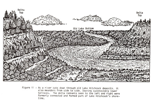
Drawing and description of river flowing through old Lake Hitchcock from Richard D. Little, Exploring Franklin County, fig. 11, p.34
These early valley residents were the ancestors of the native Pocumtuck Indian group. They were the first people to appreciate the Connecticut River Valley as a place in which to live and prosper. In years to come it would be a center both of violence and of peaceful coexistence as newcomers vied with Native Americans for control of this fertile and strategically located river valley.
Endnotes:
1The Royal Tyrrell Museum of Paleontology, The Land Before Us: The Making of Ancient Alberta (Red Deer, Alberta: Red Deer College Press, 1994) , 14-17; Richard D. Little, Dinosaurs, Dunes, and Drifting Continents: A Geohistory of the Connecticut Valley (Greenfield: Valley Geology Publications, 1989), 11, 17.
2Ibid.
3Royal Tyrrell Museum, The Land Before Us, 15. The Earth's most ancient rock dates to three and a half billion years ago, and is found in Canada's Northwest Territories. Ibid., 17.
4This essay assumes the validity of evolutionary theory.
5Little, Dinosaurs, Dunes and Drifting Continents, 3.
6Ibid., 12; Royal Tyrell Museum, The Land Before Us, 26.
7Royal Tyrrell Museum, The Land Before Us, 38; Little, Dinosaurs, Dunes, and Drifting Continents, 22-23.
8Little, Ibid., 27.
9Ibid.
10Ibid., 30.
11Ibid., 49.
12Ibid., 55; G. Bain and H. Myerhoff, The Flow of Time in the Connecticut Valley (Springfield: Connecticut Valley Historical Museum, 1976) , 9.
13Little, Ibid., 58-61.
14Little, Dinosaurs, Dunes and Drifting Continents, 35-37; American National Biography (New York, 1999) Vol. 10: 866-67.
15Ibid.
16Ibid.,
17Little, Ibid., 63.
18Ibid.; George Sheldon, A History of Deerfield, Massachusetts, facsimile of 1895 edition, Pocumtuck Valley Memorial Association, Deerfield 1983, vol. 1, p. 29.
19Richard D. Little, Exploring Franklin County: A Geology Guide (Greeenfield: Valley Geology Publications, 1989), 34. Massachusetts Historical Commission, Historic and Archaeological Resources
top of page
|


